|
RIDE
LIST OF THE PAST YEARS:
Baja / Death Valley
Spring 2010 Steamboat Springs to Encampment Wyoming & Back
Salida Co. old Purgatory Ski & The Rainbow
Trail
Sargents Co. to Salida & Back
White Wash and The Green River Cold Gyser
Dick Brass Trail System &
Iron Wash & Devils Highway
San Rafael Swell and Chimney Rock
North & South Uncompahgre Montrose
Rico
& Telluride & Lizard Head
Black Canyon Rim Ride
Westwater and Rabbit Valley
Taylor Park & Pitkin
and the Grand Mesa Trail System
Montrose & Delta Adobe Areas
Slickrock & Sovereign Trail Moab
Westwater
to Green River & Back
Agate Creek Taylor Park Baja
TIME TO START PLANNING THE NEXT RIDE:
Hello Crew, Yes another year is gone and the holiday season is about to end. Just a few notes, looks like
a winter ride may not be possible. The snow levels and amounts are putting us out of areas we usually ride. So do all
your maintenance and get ready for new year. Waiting for photos from the Agate Creek and Baja rides that took place late in
the year. Jason, I’m not sure where the disk’s are for these, but if you would pick out the good stuff, compress
to web page size, and email it to me I would be most appreciative, thanks. Enjoy the time with your families and keep healthy,
until the next ride… Andy
|
|
DELTA, MONTROSE ADOBES
For a great mid-winter
ride we head across the street for the adobes in Delta or Montrose. Both areas offer great soft adobe riding and lots of different
washes and hill climbs. Montrose adobes are trail marked and mapped for those that would like to know were they are headed.
Most all of the trails loop and return to just about anywhere you may start. For those of you looking for a place to air it
out, the dobies have a few different groups that bring in the ramps and go for big air. Not us, we prefer running washes and
ridgelines looking for hills along the way. If you are looking to get out during the winter, take a look at Delta or Montrose
for a great desert type adobe running dirt ride.
To access the Delta adobe area take Hwy 50 to the intersection of Hwy
90 go east to the Hwy 65, travel north on 65 two miles to the Cory Store, look left you will see the massive adobe riding
area and the left hand turn that accesses the riding area. Head for town and get a motel and do a day in Delta and a day in
Montrose. Delta has a Yamaha dealer located on north hwy 50, Montrose has a Honda dealer located on East Main.
|
GRAND MESA GRAND MESA NATIONAL FOREST
Grand
Mesa National Forest is the worlds highest flat-top, topping out above 10,000 ft with over 300 lakes and just as many streams;
it is mostly two track and a hunting and fishing haven. You will be riding at 8000 ft plus most all the time, so jetting before
you arrive is a must. There are many different ways to get around on the mesa through forest service roads trails and paved
roads. It is a very busy area so make sure you are licensed or forest legal because you will be checked if you are on the
main roads.
When we ride we start at what everyone calls The Corral. The corral is the nearest access point at the bottom
of the mesa and is the starting point of two different trailheads, the Eureka and the Green Mountain. These two trailheads
will take you on a 15 mile loop or a 80 mile loop. There is lots of great riding on the mesa so find a map and pack your fishing
pole and take time to enjoy more than just throttle time. To access the corral take Hwy 65 north through Cedaredge past the
water tanks to 75 Rd, go right, you will see a sign for Brice Outfitters, follow the signs past Brice Outfitters and you will
drive directly to the staging area called we call The Corral. The Mesa is a great family jeep and four wheeler destination
also. The two track trail system is well maintained with easy access and all motorized travel is welcomed. Bring a lunch,
find a fishing hole and enjoy the day.
Ride times are mid-spring to early fall, snow levels pending. Always have plenty
of water and be prepared for ever changing Colorado weather: rain, lightening, hail or snow.
|
TAYLOR PARK - GUNNISON NATIONAL FOREST
By far
the Best high alpine single track trail system on this planet. This is a must for any single tracker that wants a great
week of high alpine woodsy, rocky, always wet and rooty, fast and demanding riding. We either stay at the Taylor Park Trading
Post cabins or are camping up one of the many creeks that are nearby. Taylor Park cabins offer a nice place to spend the
week, with nice hot showers, clean rooms and a kitchen with all the needed cookware. There are many different sites that
you can get trail info about Taylor Park but I suggest the Rick Ramsey web site. Rick has great information and ride suggestions
for all levels of riders. The Taylor Park trail system is single track riding at its best. The many different types and
styles of trails can take you as far as you want to push yourself. You can day ride the roads and cross some of the highest
mountain passes in Colorado, or take on 50 miles of some of the roughest and most technical riding you will ever come across.
The Gunnison Spur, Block & Tackle, Fossil Ridge, Double Top, Deadman Gulch, Flag & Italian Creek along with Star and Timberline
are just a few of the trails you will ride while finding your way around Taylor Park. Plan as many days as you can and be
ready for changing weather. The ride season all depends on the snow levels from the previous winter months. Ride times are
usually late spring to early fall. You will be riding at 8000 ft plus most all the time, so jetting before you arrive is
a must. The two nearest cycle shops are 60 miles away in Gunnison, bring plenty of water and always be prepared for ever
changing Colorado weather: rain, lightening, hail or snow.
|
|
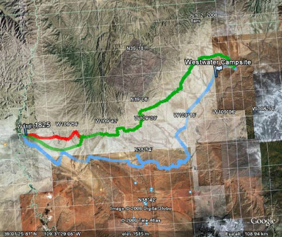
Westwater
and Rabbit Vally Area:
If you’re looking for some great desert single track than go west of Grand Junction
to Westwater Exit 227. This is a great, close place to get into large and technical desert single track riding. Lots of great
trails, plenty of all types of riding, a great winter season ride area.
|
The Dick Brass Trail System in the San Rafael Swell:
To
get to the Dick Brass Trail system you need to go about 32 miles west of Green River Utah too Ranch Exit 131. This is the
road that takes you into the Dick Brass Trail System and the infamous "Five Miles of Hell". This has to be one of the top
ten ultimate cult rides for motorcycles. You will averaging around 4 mph as you make your way along the trail, so plan on
a full day (and bring your trials bike) to get the actual 7.9+ miles in if you ride the entire trail with a 13 mile return
trail loop. There are three bailouts along the way if you breakdown, or if you have just had enough for the day. The other
single track rides in this area include the Red, Blue, Orange, Waterfall, VJ and Green trails, along with the Temple Mountain
loop. North of the interstate is a long out-and-back, two track, called "The Devils Racetrack. Fast and long this 17 plus
mile ride through canyons and wash bottoms, calls for corning and speed. Just beware of others, this is a heavy use area
for ATVs, cyclists and an occasional hiker. Just south of this area is another ride destination called Goblin Valley. The
easiest way to access GV from I-70 is to take Exit 149 towards Hanksville. If you need a large staging area for big campers,
long trailers with lots of ATVs, head for GV. Ride times for this are early spring to early winter. This area is very hot
in mid-summer and can be extremely cold towards early winter. When riding the Utah desert, make sure you have plenty of water
with you at all times, and be prepared for changing weather.
|
White Wash and the Green River Cold Gyser:
East
of Green River is Exit 175, go south to White Wash Recreation Area. Great desert riding, lots of single track, cross country
and a 3 mile, 200ft wide, sandy bottom wash, made just for speed. Large sand dunes adds to the enjoyment of this area. Find
a single track and go east to Ten Mile Canyon, or go south out the end of the White Wash to Dead Cow Trail, or get on the
single track west towards the Green River and the Cold Gyser.
|
|
|
|
|
| |
|
|